We have a BUSY spring birding schedule! So many birds to see, so little time!

The Centerton hatchery (=s shorebirds) trip is on Sunday April 25 (meet everyone at 9 AM at the hatchery). Then there is birder's weekend at Devil's Den State Park, with a field trip on Saturday May 1 (meet at the 170 bridge in the park at 9 AM) -- mostly birds of Boston Mountain forests. The following day, Sunday May 2, is LAKE FAYETTEVILLE with David Chapman -- often a big migration opportunity. Meet at 7 AM in the parking lot on the north end of the dam (near the bait shop). Here some details from trip leader, David Chapman:

Here are some further details on the NWAAS field trip to Lake Fayetteville on Sunday May 2nd. We will meet in the car park at by the dam (adjacent the bait shop) and briefly bird the dam area. We will then caravan to the environmental study center on the lake’s northshore. For latecomers who miss the carvan, turn onto Lakeview road (just north of the La Huerta Mexican restaurant) and proceed in an easterly direction about 1.5 miles. It will be necessary to park by the roadside where the road makes a sharp turn north to Springdale. The environmental study center is down a short gravel track. We will first bird the fishing pier and surrounding woodland (excellent for waterbirds and spring migrants) and then take the path eastward through the bottomlands and creeks and view these areas from the new iron bridge. The first part of this walk may be muddy if there has been recent rain. We will follow the new hard top trail around a circuit that will eventually bring us back
to the environmental center. We will walk a short section of the historic Old Butterfield Stage coach which the city has recently opened up to the public. We will pass through old fields and see the results of a recent burn conducted as part of a recent prairie restoration project. The scenery throughout this walk is exceptional and takes us through many habitats from mature woodland, scrub, old fields, and prairie, both wetland and dry habitats. Distance is about 1.5 miles and should take an hour or so depending upon how successful our birding! Anyone with walking impairs is completely welcome to move at a workable pace and go only as far as desired.
Friday, April 23, 2010
Birders find oppotunity knocking over coming weekends
Monday, April 19, 2010
Channel 5 covers Earth Day at WPWP on April 18, 2010
WPWP Earth Day 2010 covered by KFSM TV Channel 5 on April 18, 2010
Upcoming events involving Northwest Arkansas Audubon Society members
Besides the upcoming convention of Arkansas Audubon Society (in Hope, Friday April 30-May 2) with its numerous field trips & interesting lectures (check out the AAS web site for details), there are 4 immediately upcoming events in which Northwest Arkansas Audubon Society is involved. There are no charges, fees, etc for any of these events. All skills, interests, and mobility levels are welcome.

NWAAS is helping with the annual Birder's Weekend at Devil's Den State Park, including a casual & usually spring birdy walk on Saturday May 1, starting at 9 AM. I'm talking about/illustrating western birds in Arkansas in the evening at the park.

The following day, Sunday May 2, David Chapman will lead an outing to spring bird-rich Lake Fayetteville. Meet at the north end of the dam (near bait shop) at 7 AM. We'll bird this area, then drive down toward the Environmental Study Center.

NWAAS is also onboard Saturday May 8 and Sunday May 9 for International Migratory Bird days coordinated in Washington and Benton counties by Mike Mlodinow. We urge everyone available to participate. If you can help, please contact Mike: mamlod@hotmail.com.
Friday, April 16, 2010
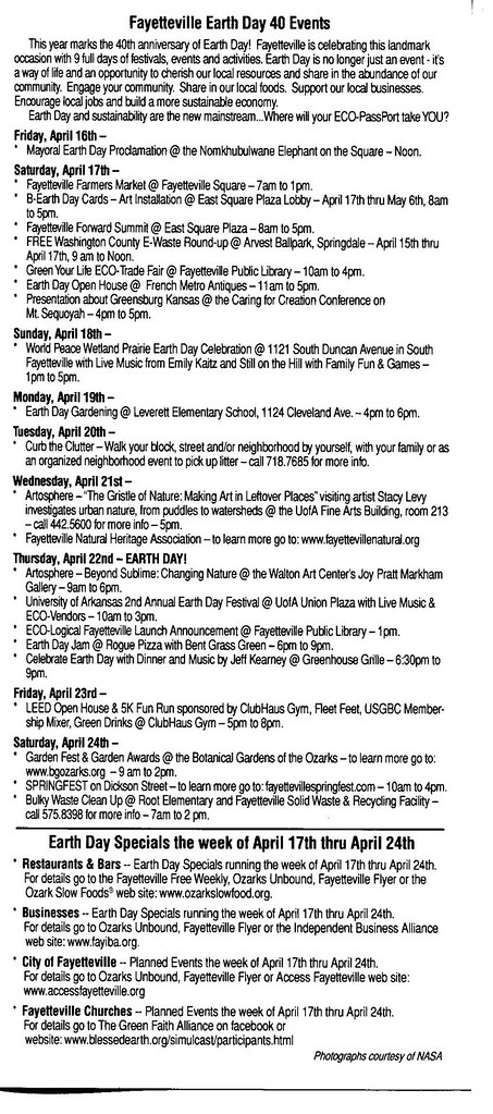
Earth Day Festival began Friday night with Caring for Creation at Mount Sequoyah; Earth Day at World Peace Wetland Prairie from 1 to 5 p.m. Sunday, April 18, 2010, offers eduction and fun for all ages
Please click on image to ENLARGE for closer view of sample photos from WPWP.

PLEASE double-click the image to ENLARGE view and ENLARGE further with your computer's tools to read small type. For more about World Peace Wetland Prairie please see www.flickr.com/photos/7295307@N02/collections/ www.flickr.com/photos/7295307@N02/collections/
PLEASE double-click the image to ENLARGE view and ENLARGE further with your computer's tools to read small type.

MANY REASONS TO PROTECT LAND SUCH AS WORLD PEACE WETLAND AND PINNACLE PRAIRIE FOREVER:
World Peace Wetland Prairie is the riparian zone of a small stream that historically was fed by seep springs and rainwater from three directions when the first westward immigrants settled Fayetteville, Arkansas. World Peace Wetland Prairie has the deepest layer of dark, rich soil in its subwatershed because leaves and other vegetative matter accumulated as the flowing water slowed and soaked into the absorbent soil and enriched that soil. Pinnacle Foods Inc.'s mounded wet prairie to the west is the main source of clean water flowing to World Peace Wetland Prairie at this time. Before the railroad was built, water flowed off Rochier Hill to the northwest and from the prairie and savannah to the north of WPWP that has been replaced by fill dirt and paving for apartments. Water from the east and north slopes of the high land where Pinnacle Foods Inc. now sits flowed to WPWP along with all the water from the high ground near 15th Street, which moved north to WPWP before flowing east to the Town Branch of the West Fork of the White River. Such remnants of prairie help keep the water where it falls and recharge the groundwater. Like the many similar remnants of such prairie in our diverse geographical area, WPWP and Pinnacle Prairie are the surface manifestation of a significant bedrock fault. Such sunken wetland is a characteristic feature that appears above geological faults worldwide. The Karst map of Washington County Arkansas shows the WPWP watershed in red, meaning that it is a critical groundwater recharge area. Preserving such depressional wetland in our city is the least expensive way to reduce downstream flooding and siltation of our water supply. Hundreds of native plants grow. Many birds and other wildlife prosper on healthy wetland vegetation. And prairie vegetation sequesters carbon dioxide and cleans the ground water.


KEEP the WATER where it FALLS!
Wednesday, April 7, 2010
Scissor-tailed flycatcher (formerly Muscivoria forficata but now Tyrannus forficatus)
Please click on individual images to ENLARGE and see Scissor-tailed flycatcher on April 7, 2010.
Use live link to read about Oklahoma's state bird:


Use live link to read about Oklahoma's state bird:


Sunday, April 4, 2010
Bluejay busy feeding on north edge of World Peace Wetland Prairie
Please click on image to ENLARGE view of bluejay on April 4, 2010.


Saturday, April 3, 2010
April 10 and April 17 outings announced and described by Joe Neal; all welcome
There are two upcoming field trips of the bird-wildflower-All Of Nature- variety upcoming in the western Ozarks, April 10 & April 17. All are free & open to the public. Mis-information I typically share on such trips also comes free of charge. Casual and hopefully fun is the goal.

On Saturday, April 10, we are joining Joy Fox and others from Wattle Hollow Retreat Center, just north of Devil's Den State Park, for an exploration of the fine Boston Mountains forest, small farm, and stream environments.
www.wattlehollow.com
 You can meet the group along highway 170, where you turn into Wattle, at 8 AM for the leisurely & birdy stroll down to the retreat center. Or, if you sleep in, just get to the retreat center at 10 AM and we'll head down the hillside forests & creek. Pot luck lunch at noon. Here are directions to Wattle:

From Fayetteville take HWY 540 south to the Devil's Den exit at the West Fork exit #53. Turn right (west) towards the park, following HWY 170 (Devil's Den Road) signs for about 14 miles. At the sign that says" Devil's Den State Park, 4 miles, " continue on Hwy 170 another half mile, there will be a 'Wattle Hollow' sign on the left, just before the driveway (there is a stone cairn also on the left, and a small white house with mailboxes on the right). This is the meeting place at 8 AM. If you are in the 10 AM group, go left down the driveway; after 1 mile, take the (only) right fork in the drive which is well-marked, and continue to the end of the road.

Type Wattle Hollow Retreat Center into Google to explore Joy's web page.

On Saturday April 17, Northwest Arkansas Audubon Society hosts a field trip to Ninestone Land Trust in Carroll County.
sarawittenberg.blogspot.com/2009/05/ninestone-land-trust.html
 Meet at 9 AM. Everyone is welcome! You do not need to be an Audubon member or an experienced observer to participate. Lunch will be pot luck style, accompanied by the waterfalls, so bring your lunch or something to share.

There is a fine Ozark stream and exceptional habitat for birds, plants, and other species. Habitats: a series of fine waterfalls over sandstone kettles, Piney Creek, classical Ozark upland fields, sandstone glades, soaring blufflines (we’ll see them from on top and see them from below), stands of both mixed hardwood species and native shortleaf pines, and the Ozark birds and transients associated with the many different habitat types. This property is being preserved to protect its unique values.

Ninestone is located just south of Berryville, off highway 21, about one hour drive east of Fayetteville. Depending upon weather conditions, there could be several shallow creek crossings. If you have rubber boots (Muck boots, barnyard boots, etc), they might be helpful. The creek, a traditional body of water in the Ozarks, also gladly accepts tennis shoes & bare feet.

This field trip works quite well regardless of your mobility condition. If extensive walking & hiking doesn’t work for you, there is plenty of high quality scenery right where we park, at the home of Don Matt & Judith Griffith. The amazing waterfalls are easily seen there and heard as well. Piney Creek is just below, with its waterthrushes plus migrants passing through the Ozarks. So you don’t need to be very mobile to enjoy all of this, plus the big native pine grove and farm yard. This is all fun & fulfilling stuff to do while everyone else is “off to the woods & fields.” We’ll all rejoin for a pot luck lunch.

Directions to Ninestone:

1.For those coming from Berryville or north- directions from intersection of Hwy. 62 E & Hwy. 21 S just east of Berryville: From Hwy. 62 east of Berryville, take Hwy. 21 South for 10 + miles to the Cedar Creek Country Store on the RIGHT. IMMEDIATELY after the store & parking lot, turn RIGHT onto a gravel road. The gravel road is CR 512, but is not well marked, so just turn RIGHT immediately after the store. Do not cross the bridge over Cedar Creek! Continue on the gravel road for 1 MILE, staying to the LEFT at any choices.
You will pass 3 mailboxes on the LEFT, one is a large blue mailbox. Continue on to our log cabin on the LEFT.

2.For those coming from Fayetteville or south- directions from intersection of Hwy. 412 & Hwy. 21 N: From Hwy. 412 take Hwy. 21 North for about 7 + miles. Cross the Cedar Creek Bridge first & turn LEFT onto the gravel road (CR 512) before you get to the Cedar Creek Country Store on the LEFT. Continue on the gravel road for 1 MILE, staying to the LEFT at any choices. You will pass 3 mailboxes on the LEFT, one is a large blue mailbox. Continue on to our log cabin on the LEFT. Judith Griffith & Don Matt, Ninestone Land Trust,
870-545-3559 waterfall@hbeark.com.
Subscribe to:
Posts (Atom)